

What is now the United States was colonized by the Dutch, Spanish, and English in the sixteenth and seventeenth centuries. The first civil settlements were dangerous experiments in creating enduring communities in a vast terra incognita. Unlike the exploratory forays of the sixteenth century, seventeenth-century settlements served agricultural, commercial, and religious ends. Although not military in function, they were frequently formed in a defensive mode, since they were vulnerable to attack from both Native Americans and competing colonial interests.
English and Dutch settlements drew their formal organization from their contemporary town planning practices in their places of origin in the Old World. These were still fundamentally medieval, with towns and cities favoring a strong, fortified nucleus focused on the church and marketplace, with an organic street pattern spiraling outward to surrounding agricultural lands. Puritan towns of colonial New England were formed from this spatial and spiritual concentricity with the church and village green as the framework for a strict social order. Individual dwellings, with their home-based cottage industries, were situated in close proximity to the center, and garden lots occupied an outer ring.
In contrast, the original tidewater colonies of Virginia and North Carolina had no such underlying social intent; they were settled to develop and organize an English colonial economy based on agricultural trade. Jamestown, a crude fortified town, was meant to function as the region's central locus of defense, taxation, and export for various tobacco farms, but owing to the decentering nature of agriculture and the lack of a sustaining social framework, the experiment failed.
The Dutch settlement on the tip of what is now Manhattan was ideally situated for trade in the New World. Like Amsterdam itself, New Amsterdam's geography provided the auspicious conditions for a city of commerce. It was located midway between the Virginias and New England, on a protected peninsula downstream from Hudson River agricultural estates and the Dutch fur-trading outpost at Fort Orange (later, Albany). The internal town organization reflected the pragmatic response to the demands of defense, trade, and dwelling, importing urban patterns and features from the Dutch landscape. The city was densely built with gabled structures and streets and canals shaped by the city's natural form, serving its commercial ends. Broadway, a major internal street stretching north from a fort at the southern tip of the peninsula, provided a connection with other Dutch settlements on Manhattan, forming a spine that would organize the city's continued growth as it passed into English and American rule during the eighteenth century.
Whereas the English and Dutch colonists of the early seventeenth century drew on medieval precedents, continental Europe had been steeped for over a century in the rational artistic theory of the Renaissance. In this classical paradigm, streets and squares were conceived in a coherent overall plan, primarily relying on rectangular and radial geometries. Seventeenth-century French urban design was typified by the regularly shaped, architecturally defined place (city square) and by broad, orthogonally organized streets with axes connecting one important palace or monument to another. This idiom, promoting royal and military display, was most extravagantly realized in Paris and Versailles.
These modern concepts did not reach the English colonies until the turn of the eighteenth century. During the Restoration, Charles II had brought home to England ideas he had absorbed while in exile in France, and he was able to explore and realize them on a large scale in the rebuilding of London after the Great Fire in 1666. A majority of the proposals for London's reconstruction used a gridiron plan, punctuated regularly with squares and grand plazas for important public buildings.
The design of two colonial American cities, Philadelphia and Savannah, owe much to the ferment of new ideas following London's disaster. The 1682 plan for Philadelphia reflected not only this new formal sensibility but was infused with the philosophy of the Quaker settlers�a religious sect seeking to establish a colony where it would be free to worship. Land comprising much of today's southeastern Pennsylvania was granted in 1674 to Quaker gentleman William Penn. Of this, a square mile between the Delaware and Schuylkill rivers was to be a new capital city, Philadelphia, "a faire and greene countrie towne" laid out in generous lots so as to avoid the perils of fire and disease so recently experienced in London. A shared vision of Penn and surveyor Thomas Holme, the Philadelphia city plan consisted of a front street on each river with two major cross-axial streets defining a city center and four quadrants. At the center was a large, ten-acre (4-ha) square to be surrounded by religious, commercial, and public buildings. The four quadrants were laid out in a gridiron of smaller-scale streets for individual house and garden lots. At the center of each of the residential quadrants was an eight-acre (3-ha) square to be used for more informal collective purposes "as the Moore-fields in London."
The city plan of 1682 was an act of intentional long-term planning, an optimistic vision of organized growth, river to river, that in Penn's words "might have Room for present and after Commers. � " Penn's vision for Philadelphia was grounded in a religious faith that was pacifist, fundamentally nonhierarchical, recognizing "that of God in all men." Such a balanced, humanistic dwelling paradigm was remarkably self-sustaining. In its early decades the city developed first along the Delaware, expanding in substantial accordance with the plan, to become the most important urban center in colonial America.
Like Penn's "holy experiment," the new city of Savannah also provided a haven for the oppressed. Those who migrated with reformer James Oglethorpe to the new colony in Georgia were debtors and persons of modest means who took advantage of the unique opportunity to start afresh in the New World. The city charter of Savannah employed a system of town and country land allotment similar to Philadelphia's and thereby established the beginning of a broad regional plan.
The city was sited on a plateau above the Savannah River ten miles (16 km) from its mouth. The city and its outlying garden plots and farm lands were laid out using the gridiron organization. Within the city, the grid became highly differentiated in a pattern of smaller autonomous units called wards, each of which contained at its center a formal square with trustee lots for grand homes or public buildings. A hierarchy of streets and building lots completed the inner and outer perimeters of each ward. When aggregated, the wards created a unique fabric of alternating built and open space and a series of internal visual axes, which would provide the urban structure to support the city's incremental expansion.
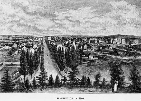
Eighteenth-century colonial towns and cities employed the pattern of orthogonal streets and central public square as much as geography would permit. Boston was a notable exception, using instead a loosely radial geometry in response to the contours of the neck of land on which it was situated. When the new nation emerged as an independent state, a full palette of neoclassical, indeed baroque, planning devices was brought to bear on the new capital, Washington, D.C. In 1791, Frenchman Pierre Charles L'Enfant created a plan for the city that drew heavily on the examples of Andr� Le N�tre's Versailles and Christopher Wren's well-known plan for London. Overlaid on a regular gridiron of streets was a grand web of axial avenues that emanated from the two major seats of power: the "Federal House" (the Capitol) and the "President's Palace" (the White House). The plan provided for a "Grand Avenue" (the Mall), expansive public gardens, water features, many squares and plazas with monuments, and elegant neoclassical buildings with areas of commerce at some remove from the places of visual grandeur. Unlike other American cities of that time, Washington, D.C., was unabashedly designed as a place of beauty; it was meant to inspire awe and to invoke the power of a new democracy derived from an ancient model.
With the struggle for independence successfully resolved, the nation was able to grow and develop. Expansion on all civil fronts took place: population increased, trade and industry flourished, and people became educated and owned land at an unprecedented rate. Established cities grew and planned for future growth, using the simple gridiron street plan and row-house typology as the primary urban pattern. The 1811 Commissioner's Plan for New York City, the landfill reclamation of the Back Bay in Boston, and the expansion of Philadelphia and Savannah in the early decades of the nineteenth century reflect an attitude toward urban growth that was chiefly concerned with expediency. Rejecting the richer patterns of space inherent in the early city design, the city planners adopted the simple grid as a convenient tool for land transactions.
On a large scale, the same device was used to claim and lay out the vast western territories acquired in the Louisiana Purchase. Thomas Jefferson, under whose auspices the meting out of western territories began, held a belief in the moral superiority of the agrarian life. His democratic ideal seemed to conflate well with the dispersion of population across the landscape rather than in dense urban settings, a bias that remains part of the national idiom. Jefferson's influence on the shape of the American landscape and way of life reflects a combination of two paradoxical tendencies that are deeply American: the romantic Rousseauistic view that man is in his most pure state when at one with nature, and the Cartesian view of the universe in which all things are knowable through objective and rational delineation.
The western states were settled amid the rush and profit of land speculation with the efficient, familiar, and uniform gridiron plan as its parceling tool. Like the military encampments from which the gridiron derived, it could be applied universally and without intimate knowledge of the land on which it was projected. Railroads forged westward along orthogonally platted terrain, spawning towns and cities. The grid was most plausible in the flat prairie states, but it was used even in such places as San Francisco despite challenges presented by natural topography. Conceptual plans for new state capitals often included some baroque design elements, but most elaborate plans were not realized, in the flurry of private profit-taking.
The development of Chicago reflects nineteenth-century opportunism. In 1833 it was a rough town clinging to the swampy shores of Lake Michigan, driven by the prospect of a proposed canal that would provide a vital transportation link with the East, doing for the Midwest what the Erie Canal had done for the cities in upstate New York. Chicago's hastily erected wood buildings and unpaved streets gave it the appearance of a temporary encampment, and its population�mostly male�hovered at about 400. On the strength of canal speculation, population grew to 1,800 by 1834 and to 4,000 in 1836. It recovered from the crash of land values in 1837, and by 1848 the canal was built and the city had a population of 20,000. But the importance of navigation was soon outstripped by railroads, and by 1865 the fabric of Chicago's rail system had been laid down. Railroads feeding through the city made Chicago the nation's central hub, which profited from westward expansion.
While the West was being settled, the eastern seaboard continued to flourish. Mill towns sprang up along rivers taking advantage of water power to manufacture their goods, such as textiles, shoes, guns, and so forth. These were in turn transported via canal or the burgeoning rail system to the large seaboard cities for distribution. New York, Philadelphia, Boston, and Baltimore became great centers of commercial activity, with shipping industry in its heyday at midcentury and railroads gaining as the great mode of transport. The economy of the Southern states was still based on the neofeudal plantation system. The production of tobacco, rice, and especially cotton relied on slave labor to flourish on a grand scale. Raw materials were shipped by sea from New Orleans, Charleston, and Savannah, and by rail from the new city of Atlanta, Georgia to the industrial centers of the northeastern United States and England for processing and further distribution.
The Civil War had a devastating impact on the landscape and the economy of the South but had quite the opposite effect in the Northeast, where a heavy industry was propelled forward by military exigencies. The creation of a complex and extensive rail system, the mining and transport of anthracite and other minerals, the production of steel, and the construction of heavy machinery, weapons, locomotives, and ships were all results of an accelerated industrial economy that would continue to boom well into the next century. Moreover, waves of immigrants from Europe fleeing political oppression, poverty, and famine began to arrive in the port cities of the eastern seaboard seeking opportunity promised by the phenomenal economic and geographic expansion of the United States. Soon to be followed by former slaves from the South, these immigrant populations were indispensable to the creation of the great industrial cities and to the settling of towns and the cultivation of farms in the American West.
The post-Civil War period was a time of extraordinary urban growth and prosperity for capitalists in the North. Industrial Philadelphia became the "workshop of the world," with great factories lining the rail corridors that crisscrossed the northern districts of the city. Block after block of brick row houses sprung up for the workers and their families. In three decades what had been a landscape of stream-laced woodlands had become completely built up; a uniform gridiron had replaced the humanizing influence of William Penn's plan for intermittent city squares. New York City likewise expanded northward into its previously platted grid of streets.
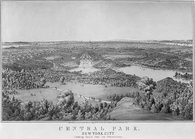
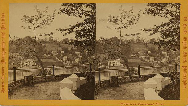
Denser still than Philadelphia, a built-out Manhattan would have become one of the most suffocating places in urban America had it not been for the incredible foresight of the planners of Central Park. In 1857 landscape architect Frederic Law Olmsted and his colleague Calvert Vaux began work on the 500-acre (200-ha) public park, stretching almost fifty blocks to the as-yet-undeveloped districts uptown. Using the existing character of the site as their guide, they created a naturalistic composition of lakes, meadows, cliffs, and woodlands for the enjoyment of all the people of New York City.
The concept of this great urban oasis was neither without precedent nor disconnected from a larger current of thought. Indeed, the great urban parks of continental Europe and the work of landscape designers Humphrey Repton and Capability Brown were well known. Moreover, the Romantic ideal that proclaimed the purifying influence of nature on man�already deeply rooted in European arts and culture�began to have greater currency and meaning in urban America. As more and more land was consumed by the rapacious forces of industry and land speculation, a nostalgia for the lost innocence of the Arcadian world gripped the American sensibility.
The development of park systems within the cities and of suburban enclaves at their perimeter would profoundly influence the shape of the American landscape. It reflects as well the strong cultural proclivity to escape from harsh urban life into a bucolic environment, artificial or not. Indeed, these "natural" landscapes were as self-consciously designed as were the geometric compositions of classical urban design. Both park and suburb employed informal curving roads, rough-hewn materials that evoked a preindustrial past, and patterns of planting and land contour that manipulated spatial sequence and experience to conceal, reveal, and delight. Boston, Philadelphia, and Baltimore soon had major city parks. And these cities as well as Chicago, Cincinnati, and Detroit had developed picturesque, bucolic suburbs for the upper-middle class.
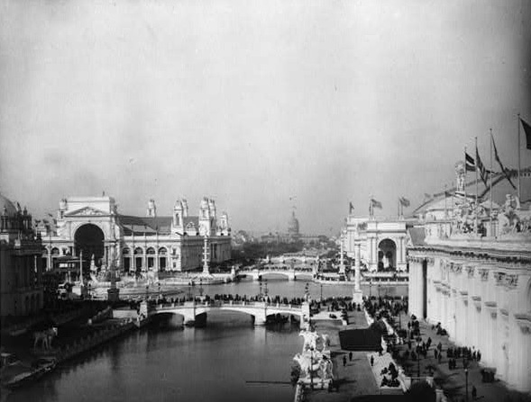
Toward the end of the century, a further antidote to the dreariness of the monotonous grid of American cities was introduced through the City Beautiful movement. This aesthetic movement was born of the first generation of American architects to be professionally educated in Europe, who had experienced Hausman's Paris firsthand. In pictorially classicizing forms, the City Beautiful movement reintroduced the baroque city design that had been left waiting in the wings for almost a century since L'Enfant's design of Washington, D.C.
The Chicago World's Columbian Exposition of 1893, a temporary installation featuring monumental white structures in cross-axial spatial composition, captured the imagination of planners and leaders who sought a greater sense of grandeur for their cities. Daniel Burnham and other architects from the �cole des Beaux-Arts in Paris drew up proposals for Chicago, Washington, D.C., San Francisco, Philadelphia, and New York. Most were only partially realized, but the legacy of grand avenues and vistas terminating in monumental compositions of building and sculpture are a defining aspect of the American city today.
A crisis of overcrowding, pollution, and the deterioration of already aging physical infrastructure began to plague the large "gateway cities." During the Progressive Era at the beginning of the twentieth century, housing reform was enacted in many cities in order to protect the health, safety, and welfare of the citizenry. In the 1910s and 1920s, zoning legislation was introduced as an aesthetic device protecting the interests of the wealthy from the intrusion into fashionable areas by unwelcome industry and unsavory populations. A powerful, although crude, tool in planning the American city, zoning laws grew to regulate land uses and their adjacencies, building height and lot coverage, and dwelling densities.
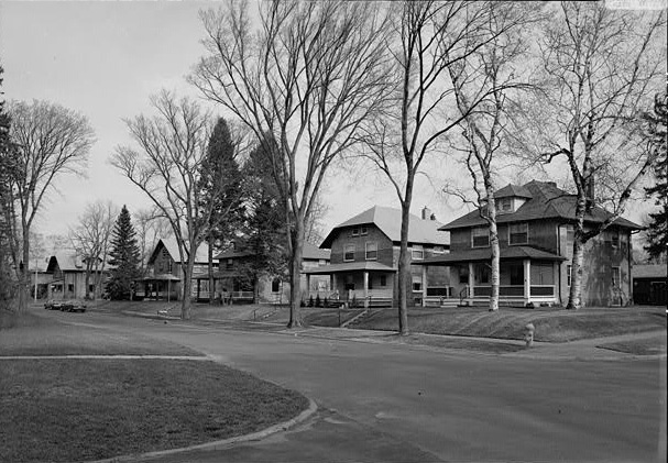
In the face of the continued population growth and the imposition of zoning controls, new strategies for residential development outside the urban core were needed. Of the many social utopian models cultivated in Europe, Ebenezer Howard's Garden City concept of 1898 was the most influential. The Garden Cities were cooperative satellite villages linked by rail to large urban centers, providing their inhabitants with the best aspects of town and country. Each was formed in concentric rings, with the formal civic center ringed by clustered housing, industries, and workplaces and by an agricultural greenbelt. Garden City design principles were applied to such places as Yorkship near Philadelphia; Sunnyside in Queens, New York; and Morgan Park near Duluth, Minnesota. Yet they lacked the vital social ingredient of a shared economy and self-government, and the American Garden Cities became expressions more of protosuburbanism than the vision of a new social order.
The modernist design revolution that had erupted in Europe following World War I did not affect American urban planning and development until the mid-1930s. The Depression-era economy could no longer afford the lavish forms of Beaux-Arts architecture, and the public sector became, by necessity, the benefactor of most urban projects, notably those having to do with housing the newly destitute. Early public-housing schemes were of a scale and formal language amenable to the existing neighborhood contexts. However, by the late 1940s the economies of scale and the lure of minimalism conspired to encourage the construction of new mass-housing schemes that broke with even the humblest traditions in urban dwelling form. The shining modern towers that took the place of acres of substandard row housing would soon become decrepit, dangerous, and obsolete, occupied by only the poorest, most dependent segment of society.
Another utopian proposal for American dwelling was Frank Lloyd Wright's Broadacre City, a twentieth-century iteration of romantic, Jeffersonian agrarianism. Born of the Midwestern prairie, Wright was a committed antiurbanist, claiming that democracy could only be realized through the individualism and self-sufficiency that could thrive in a planned physical structure of decentralization. In Broadacre City the single-family house, sited at the center of its own one-acre farm lot, reflected Wright's belief in the organic supremacy of the nuclear family. Private automobiles (and even helicopters) provided transportation, and the regional centers of commerce where farm products could be exchanged were located at the freeway interchanges. This was a regional concept, and the "city " was itself multicentered and dispersed. In a stroke of frightening misinterpretation, Wright's vision helped to inspire the mass suburbanization that would take place following World War II.
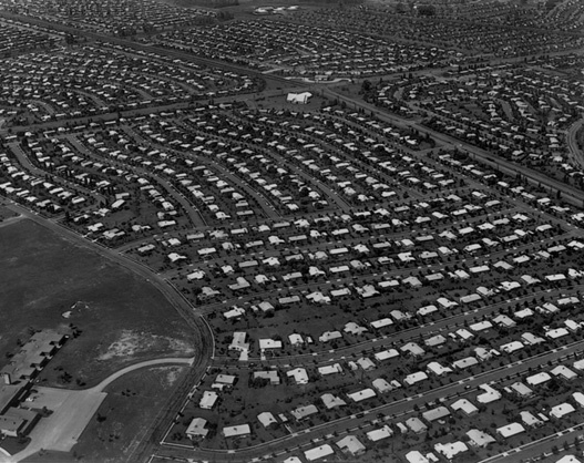
World War II brought the United States out of the Great Depression. Economic development naturally focused on industries related to the military, but despite the public sector's involvement, housing production and maintenance of the existing urban fabric had fallen dangerously behind. When the soldiers returned, the United States was facing a monumental housing crisis. As a means of stimulating the private building industry, business loans and home mortgages were made broadly available for the construction and purchase of new, single-family homes. Simultaneously, the federal government financed construction of a vast highway system that provided access to lands for suburban development, making the private automobile a necessity. As suburban real-estate development exploded during the 1950s, massive schemes such as Levittown (planned communities in New York and Pennsylvania) transformed agricultural lands at the outer reaches of the large urban centers.
Like the satellite village of the Garden City and the gleaming tower of the modernist city, the decentralized vision of Broadacre City was adopted in superficial form only. Indeed the family farm that was at the heart of Wright's democracy was virtually eradicated in the mass suburbanization of the postwar period. The relentless subdivision of open lands into a dense but decentered suburban landscape radically transformed the national geography in the second half of the twentieth century.
Nowhere is this trend more purely manifest than in Los Angeles and Orange counties in southern California where formless "cities" sprawl across the landscape. Homes, workplaces, and schools are dispersed. The automobile is required for daily commutation to the workplace and all other activities, creating a dense web of roadways, private driveways, and parking lots. Where pedestrian circulation and public-transportation systems once brought strangers into regular contact, car culture has had an isolating effect. Moreover, built expressions of a civic culture have devolved from the realm of public city centers to the privately owned, internalized world of shopping malls. These are often located�as Wright would have had it�at a freeway interchange, but consumption of goods rather than their exchange has placed the citizen in a passive rather than an interactive role.
The mirror effect of mass suburbanization was felt acutely in the cities, where deteriorating working-class neighborhoods were abandoned by those who could pursue the "American Dream." Those left behind were disproportionately African American, Latino, or other economically disadvantaged groups. Moreover, the industrial economy had collapsed, unskilled jobs were no longer available, and banks excluded whole areas from home-mortgage and small-business loans, making inner cities places of desperation. The riots of the mid-1960s brought the issue to crisis but also sealed the fate of the inner city. Federal investment in core urban redevelopment, meager as it had been, was drastically reduced in the 1970s, and American cities continued to depopulate.
New directions in planning and urban design have emerged since the 1960s in response to pragmatic needs and a critical assessment of American culture. Slowly Americans have recognized that in the fury to fulfill their "Manifest Destiny," they have occupied territory rather than created places. As densely populated as the nation has become, Americans have yet to develop a nuanced language of collective form that sets a stage for civil and democratic public life. A sense of the limits of resources, including geographic space�first an environmental issue�now defines the movement for "sustainable" cities.
The sprawling development practices that plague the American landscape with traffic, pollution, and spatial fragmentation are slowly being challenged and reversed. Inheritors of the Garden City tradition, "new urbanist" developers and designers have proposed models of towns formed to promote the sense of community missing from typical suburban development. New towns such as Seaside and Celebration in Florida emphasize a strong, well-defined town center, increased housing density, and a hierarchy of streets that encourage pedestrian contact. This formula has had significant success in supplanting the older suburban model, but in a fundamental respect it is the same. It is most attractive to the private developer where a clear "greenfield" site is used and a fairly homogeneous middle-class population is to be served.
The great challenge for the paradigm of sustainability is in confronting the American obsession with newness, uniformity, and privatization in existing contexts. It requires a fundamental recognition that urban text is a constantly evolving organism that must be maintained, rewoven, and periodically reinvented. Having begun a reflective course with the historic preservation movement of the 1960s, urban designers now must embrace and reinvent difficult sites: residual spaces between and below highways, decaying waterfronts, crumbling neighborhoods, abandoned industrial "brownfields," and postindustrial shopping centers.
As urbanists bring twenty-first-century land uses and patterns of inhabitation to these sites, they do so recognizing the strength that multiple layers of formal expression confer on a place. Similarly, by reintroducing natural ecological systems suppressed during the rapid growth of gridiron cities, a dialogue can be reestablished between nature and urban form. This approach is contrary to the practices of mass culture that have defined so much of the American landscape. Fashioning unique, meaningful space from existing contexts is labor-intensive, and it requires the participation of already invested constituencies. But in the careful process of reweaving an urban fabric, new public space that reflects its diverse texture can emerge, bringing with it a more democratic interpretation of American civic life.
Design, Commercial and Industrial
American Landscape and Architectural Design 1850-1920 (Library of Congress American Memory)
Language of the Land: Journeys into Literary America (Library of Congress)
Great Buildings Collection: Architecture in an Urban Context
Immigration to the United States: Urban Planning
A Digital Archive of American Architecture
America on the Move (Smithsonian)
Encyclopedia of American Studies, ed. Simon J. Bronner (Baltimore: Johns Hopkins University Press, 2018), s.v. "Urban Planning and Design" (by Sally Harrison), http://eas-ref.press.jhu.edu/view?aid=17 (accessed August 23, 2018).


